Sunday, September 12, 2010

The Final Miles

Native American fishing platform, The Dalles, OR
Native American fish platform, The Dalles Dam in the background
Maya Lin's Confluence Project, Pasco, WA
Columbia River Reach near Hanford
Columbia River near Wanapum Dam
September 9 and 10, 2010
Near Dalles, Oregon

During the last two days of our trip we saw the Columbia River “wild” at the Hanford Reach National Monument, the confluence of it and the Snake River at Pasco, and finally watched it get wide and lazy from all the damn control. Pun intended.

Because we wanted to avoid construction delays we drove home on the Oregon side along the Columbia River Gorge National Scenic Area. At the Dalles, OR we discovered many Native American fishing platforms and climbed over jumbles of rocks and skinny trails to photograph them.

Here are some photos from the last two days of our trip.

I’m going to write an article about this trip for the “Columbia River Reader”. It will be published in the Nov. 15 edition. Wish me luck!

Thursday, September 9, 2010

Religion and a Restaurant

Waiting for funding for a new cupola
Message from the Presbyterians across the street
Keeping cool in summer and warm in the winter
Hardware and Cafe Entrance
Hunters Cafe and Hardware with a little church thrown in
September 8,2010
Moses Lake, WA

Today we traveled along Lake Roosevelt that was created by the Grand Coulee Dam. It is 129 miles long ,beautifully serene with sagebrush and golden bunchgrass covering the shores. It is designated a retirement/recreation area, and 54% of the population in this area is over 65.

We stopped at Hunters, WA, population 305. We wanted coffee, and saw a sign advertising espresso. I saw a white building that looked like a church with lots of cars parked next to it. I said, “must be a funeral today.” Nope. It was the Catholic church transformed into a hardware store/ restaurant/coffee bar. I heard a new trinity: bean, bolt, bowl of soup. According to the locals the church had been “decommissioned” (I think he meant deconsecrated) in the 1970’s, when the Catholics built the “old stone church” up the hill.

Some part of me did appreciate the bad, cheap remodel, and I laughed at the air conditioner sticking out of the top of the arch in the church window. The espresso machine sat exactly where the altar used to be, and to the left of it was the restaurant’s stove. Puts a new twist on hell’s fire, doesn’t it! Are the wages of sin decaffeinated coffee? The woman who owns the restaurant told us that she is convinced that that place where her espresso machine sits is still holy, and I believe it, too! God works in mysterious ways.

Today’s Route: WA Highway 25 to Miles, then WA Highway 17 to Moses Lake.


Tuesday, September 7, 2010

Rivers Like Conceptual Art

Confluence of the Kootenay and Columbia at Castlegar, B.C.
September 7, 2010
Kettle Falls, WA

Here is a link to the 1,242 mile journey the Columbia River takes:

In 50 degree temperatures and rain we left Balfour and drove south following the west arm of Kootenay Lake with the Silkirk Mountains and Kokanee Glacier on our left and the Purcell Mountains beyond them. There was more housing, more traffic, and more commerce as we neared Nelson, B.C., a town proud of its heritage and historic character. At Nelson we crossed the bridge where the lake severely narrows and becomes Kootenay River. Now the Kootenay is poised to meet the Columbia 30 miles south at Castlegar.

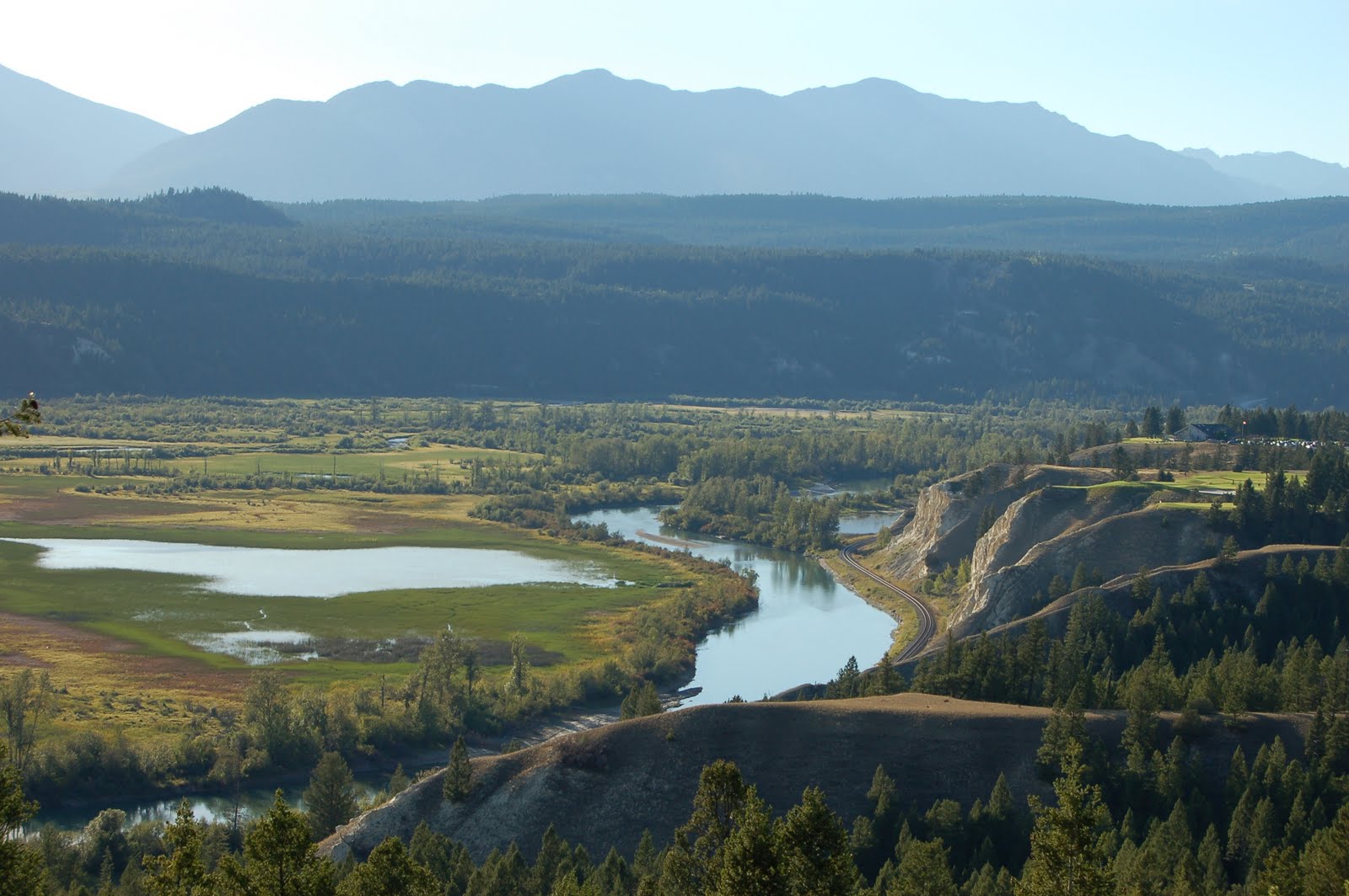
Let me brag. I am such a good navigator and so proud of my skills. I took a local map and got us to Silkirk College in Castlegar where I could see there were hiking trails down to the river, and I was sure we would be able to see the confluence of the Kootenay and Columbia from that point. Bingo! We pulled the truck and trailer into a far parking lot on the college campus, saw a break in the grass, inspected it and decided this was indeed the trail, and started walking. Bingo again! This well maintained path took us to the exact point where we could see the meeting of these two rivers not too far in the distance, and I was pleased all around.

Dale is a wonderful traveling companion, and some of our best travels have been road trips. He maneuvers the truck and trailer like they are ballet dancers, and he is patient and likes my mission(s). I understand him better and appreciate him more each day of our journey. We have our moments, however, but not today.

I’m beginning to think that headwaters and confluences are like conceptual art because the beauty, grandeur and understanding is more in the idea than it is in the tangible thing. At the confluence of the Kootenay and Columbia there was no fanfare, no bright lights, no geological or historical markers, just the simple union of two bodies of water, but I was both exalted and moved to see what had become of the marshy, spongy, water I saw at Canal Flats. I was quiet and contemplative at the headwaters, and now at this major meeting place I was thrilled and breathless by the power the river had gained.

My sister and I both say that we are such sentimental fools that we even cry at grocery store openings. When we crossed the border back to the U.S. today the customs official welcomed us home, and although we’d been in a “not so un-American Canadian province” for only 7 days, my face got hot like it does just before I cry. I’m glad to be home.

Today’s Route:
Canada highway 3A from Balfour to Castlegar, Canada 22 to the border and it become Wa Hwy 25 that is a scenic highway along the Columbia River to Kettle Falls, WA

I


Monday, September 6, 2010

Columbia Lake and The Source

The Columbia River begins at the south end of Columbia Lake at Canal Flats. There the lake is spongy and marshy and fed by underground streams. The lake is eight miles long and a little over one mile wide and only about 15 feet deep. The altitude at Canal Flats is 2650 feet. At the north end there is a depression where the water from the lake spills over and creates the wetlands that eventually become the Columbia River. It's a miracle!
Columbia Lake from Columbia Lake Provincial Park
Highway 95 View Point near Canal Flats
Columbia Lake in the distance, and the wetlands in the foreground
Another view of Columbia Lake and the wetlands. One third of the way from the top and in the center of this picture there is a concave contour between the wetlands and the lake and Dale and I think that is the spillway.

Near the Source of the Columbia River

a family fishing about one mile from the source
2 miles from source, river is a foot or two deep
Fishing 2 miles from source at Fairmont Hot Springs


About 2 miles from the source at Fairmont Hot Springs, B.C.

The Columbia River has been designated as a Heritage River by British Columbia.

Columbia Wetlands


The Columbia River Wetlands are the longest continuous wetland remaining on the continent. The area is 64,000 acres and supports 260 resident and migratory species of birds. It stretches from Canal Flats to Donald, B.C. These photos were taken from a view point along Canada Highway 95 between Spillimachaen and Brisco.

Columbia River Scenes

Confluence of Columbia and Kicking Horse River, Golden B.C.
Columbia River at Revelstoke, British Columbia
Confluence of the Wenatchee and Columbia Rivers, Wenatchee, WA

Indulging a Whim

detail
Wall around house
detail of glass bottle bottoms
Near the front door

September 6, 2010
Balfour, B.C.

It was cloudy, cold, and occasionally spitting rain so we decided to stay put at our RV spot on Lake Kootenay, and instead of following the Columbia we decided, in the words of retired undertaker David Brown, “to indulge a whim of a peculiar nature.”

David Brown was green. He thought something ought to be done with the used glass embalming fluid bottles he and his colleagues used everyday in the mortuary business so he decided to build a house with them. When he retired in 1952 he moved from Alberta to build his new home on the rock outcroppings along the shore of Lake Kootenay in Boswell, B.C. He put 250,000 miles on his car collecting the 600,000 bottles he needed to build the 1,200 sq foot house. The house is in a three leaf clover design for strength, and he left the screw on caps on the bottles for insulation. The house has been tested and it has an R60 insulation factor! It took him a year to build the house he and his wife lived in, and he spent the next 16 years there constructing terraces, turrets, bridges, and planting an extensive flower garden.

It's funny, yet impressive, and the since the interior has changed very little since 1953 some of us were quite familiar with the furnishings and kitchen design. What a way to spend Labour Day!

And about the Harmonized Sales Tax in Canada…….the Canadians are MAD! Everyone is complaining and in order to get rid of it each province will have to vote it out. B.C. now has 700,000 signatures to get it on the ballot, and put it to a vote.

Sunday, September 5, 2010

Rain Rain Go Away

September 5, 2010
Balfour, B.C.


It was a cold, rainy morning as we prepared “The Attachment” for leaving, and it didn't change until we took the ferry across Kootenay Lake and arrived at Balfour about 6PM. The landscape was obscured by deep, low clouds, and our wind shield wipers worked non stop. That is my news for today.

However I have a correction from yesterday’s post. Although the view of the headwaters is not designated, the area where we drove and hiked yesterday to see it is called the Columbia Lake Provincial Park. Our directions came from a fisherman, but these are from their website:

Columbia Lake Provincial Park is located in the Columbia Valley of south eastern British Columbia approximately 2 km south of Fairmount Hotsprings and 3 km east of Hwy 93/95. The 257 hectare park lies on the eastern shore of Columbia Lake.
Access: Turn off Hwy 93/95 at the Fairmont Creek Road (across from the Riverside Gold Resort). Travel east for 0.4 km. Turn right on the Columbia River Road. The park is located 1.6 km south along this gravel road. Two rough gravel roads intersect the main road and allow for vehicle access within 20 metres of the lakeshore

Today’s Route: Canada Hwy 95 South to Yahk, Canada Hwy 3 West to Creston and then along Canada 3A along Kootenay Lake. We took the ferry across the lake at Kootenay Bay to Balfour


Saturday, September 4, 2010

The Beginning

September 4, 2010
Canal Flats, B.C.

A brief post from Fairmont Hot Springs coffee shop after our all morning introduction to the headwaters of the Columbia River. Briefly and excitedly: it begins at the north end of Columbia Lake where the land gives way (the words big and easy come to mind) and water from the lake seeps, surfaces, meanders, and finally finds its focus in a single stream about 5 feet across. It is so quiet we heard the flapping wings of the Canadian (must be - because that‘s where we are) geese in the shallows. Serene, green, deep blue, curves, slow organic maze, unhurried, primitive, and humbling………sentences not forming just now

There is no formal park or sign or anything to let you know so we got directions from a fisherman who was trying to catch rainbow trout further down the river. Away we went on a rutted, narrow gravel road that brought us both near enough to get in the water and high enough to get an overview until we had to turn around at a fence and a “NO TRESPASSING” sign. There is a soft, but definite place at the edge of the lake that will never show up well in a photograph, but we both could see it and said, “That’s the place.”

This is Geology 101 in action!

Photos soon!

Near the Source

September 3, 2010 Part 2
Canal Flats, B.C.


Today we drove about 200 miles from Revelstoke to Canal Flats. At Revelstoke the Columbia River meets the Illecillewaet River. The water was 300 feet wide, clear blue/green with visibility to 20 feet and calm and lake like because it is controlled by the Mica dam above. The depth fluctuates with seasonal needs and local folks fish for dolly vardans. It is a source of hydro electric power for the area.

We continued on the Trans Canada Highway 1 in what Dale describes as competitive driving mode. It’s a busy, fast moving artery with semi trucks, cars, motorcycles, and tour buses moving in and out of passing lanes. We crossed Rogers Pass at 4300 feet with glacial mountains and immense green and granite all around us. The avalanche chutes can be several miles long, and wide enough that I felt they might qualify as a small city. There are 18 places along this highway that are used to position the howitzers that blast the snow in the winter to control these avalanches.

This is the largest, most expansive mountain panorama I’ve ever seen. I cannot even begin to understand the massive geological episodes that created this and the surrounding mountain terrain. This is the birthplace of 20th century mountaineering, and I can see why. In the 1920’s Swiss mountaineers were hired to teach the Canadians and Americans how to climb this complex, challenging mountains.

At Golden we had the road to ourselves. Also at Golden we saw the confluence of the Kicking Horse River and the Columbia. The river is milky, glacial, blue green, almost celadon and moving freely and swiftly. The Columbia Wetlands begin a bit north of here and extend about 80 miles south to Columbia Lake where the river begins

This 80 mile stretch of river and wetlands parallels Canada Highway 95 from Golden to Canal Flats. For most of it the river is a mile or so in the distance and inaccessible. The highway is above the river, and I didn’t understand the immensity of the wetlands until we found a view point just outside Radium Hot Springs, and I hiked the trail to the overlooks for panoramic views and photo ops. I was filled with the beauty of the slow, lazy, river carving its body around the land and the sensual concave/convex union they found together. The wind blew, and there was no one else there but me. I was in love.


Today’s Route: Trans Canada Hwy 1 from Revelstoke to Golden B.C. and Canada Hwy 95 to Canal Flats B.C.

Friday, September 3, 2010

Continuing East

September 3, 2010
Revelstoke, B.C.

After a walk about and a photo shoot of the Columbia River at Revelstoke we’ll head east on the Trans Canada Highway with the town of Canal Flats as our goal. We’re staying at a RV resort on the Kootenay River over the Labour Day holiday. It is close to Columbia Lake where the Columbia River begins.

We’ll be without cell or WiFi, so please stay tuned. I’ll post words and pictures when I can.

We’re learning a lot about (phonetically aboot) the Canadian monetary system: The USD is par with the Canadian dollar, however most goods and services are 10% to 20% higher than in Washington State. Then there’s the 12% sales tax added to every purchase. It’s named the “Harmonized Sales Tax” HST for short, but it is not music to my wallet.

Posting from a great bakery in Revelstoke where we’re eating warmed berry cobbler with yogurt on top. There is a warm loaf of multigrain bread that we’ll take along with us for lunch. The debit machine says, “Bonjour”, and I can get a croque monsieur (the French version of a ham and cheese).

North from Congestion

September 2, 2010
Revelstoke, B.C.

There was frost on our windshield this morning, but we had blue sky and sun all day. Leaving Okanagan Falls and Skaha Lake where we think the Okanagan River begins we head north along the 80 mile length two mile width. It is a beautiful glacial lake, but from Penticton it was a tedious 45 mile drive with only strip malls, chain stores, high rises and traffic lights that left us tired and our spirits drained. Beyond the transportation spine it is still wine country and an area filled with orchards of fruit and fields of vegetables. Although the landscape is concrete and billboards there are short intervals of lava-layered canyon walls against the deep blue lake.

I couldn’t figure out why there was all this depressing overdevelopment until I read a brochure that told me that this is Canada’s hottest climate and boasts more than 2,000 hours of sunshine a year. This is a booming stretch with opulent homes on the lake, upscale retirement communities, and a squeaky clean, well manicured presence.

At Vernon the population density dropped away, and we passed many emerald green lakes bordered by soaring pine, fir and aspen filled mountain sides. The space was immense, and felt bigger, rougher and more remote than the Northern Cascades. In the distance we saw the Purcell Mountains with “termination dust” (the first snow that ends, terminates summer), and in Revelstoke we saw the Columbia River again.

Today’s Route:
CA 97 North to Sicamous where we turn east and the highway becomes Trans Canada 1 to Revelstoke


Wednesday, September 1, 2010

Landscape Dead and Alive

September 1, 2010
Okanogan Falls, B.C.

Before we left the campground in Wenatchee we walked three miles of the 10-mile walk or bike Apple Loop Trail around the city. Our walk took us through the Horan Natural Area to the Walla Walla park where we saw the confluence of the Wenatchee and Columbia Rivers. This man-made wetland area with its interpretive trail, eagles, shore birds, and the sound of loons is another feather in Wenatchee’s cap.

We followed the Columbia River north from Wenatchee on the east side of the river until we reached the Okanogan valley where the river goes east and we continued north. This stretch of placid water reminded me of a quarter mile wide lake because it is water harnessed by the Rocky Reach and Wells dam. Dale said, “Parts look dead and parts look alive.” The “dead” parts are the tumbled, jumbled upheavals of granite that have been exposed by millions of years of wind, water, ice and snow, and the “alive” parts are the verdant, irrigated orchards below. The contrast is breathtaking, and I never tire of it.

This landscape became low scrub, sage brush and barren when we arrived at Pateros Lake, but became lush again in the Okanogan Valley. After we crossed the border into Canada vineyards dominated.

Today’s Route:

WA and CA Hwy 97 from Wenatchee to Okanogan Falls, B.C.

Diving In

August 31, 2010
Wenatchee, WA


In today’s newspaper my horoscope said: “You’ll dive in even though you don’t know what to do exactly.” That’s the truth, and an apt slogan for the beginning of this journey. Dale and I have talked about driving to see the headwaters of the Columbia River for a long time, and we’re finally on our way. This river fascinates me, and I’m excited to not only take this trip, but to be able to write about it for the Columbia River Reader. I don’t know what shape this adventure will take or the article that I write about it, but I’m happy to be in the water.

It rained all day. Heavy rain, then foggy with more rain over Snoqualmie Pass, and then even heavier rain with temperatures hovering around 50 degrees. We stopped for the night at the Wenatchee Confluence State Park where the Wenatchee River meets the Columbia. It was 60 degrees and dry, and we were surrounded by an open landscape with levels that built from the river to shelves of orchards with deep green fruit trees with sculptured, scrubby ochre hills behind them. Beyond those contours the atmospheric gray mountains looked small against the big, smeary, slate blue clouds that threatened but didn’t produce. At dusk the screen door of the trailer slammed shut, and I felt the last warm winds of summer.

We were very impressed with Wenatchee and the surrounding area. It has a vibrant downtown, The Toyota Convention Center, art museum, and performing arts center and the famous Apple Blossom Festival in the spring. At the campground we were told that the city is carefully managing population growth in order to preserve the orchards.

The campground didn’t have WiFi, but the Lone Pine Fruit Stand on the Columbia River where we’re eating lunch does so I’m posting from here. We’re buying fruits and vegetables and heading north to the Okanagan Valley. What a world!


Today’s Route:
I5 to WA Hwy 18E to I90E to WA Hwy 970 just south of CleElum, then WA Hwy 97N to Dryden and WA Hwy 2/97 to Wenatchee and the Confluence State Park